Seismic monitoring of groundwater variations beneath the Great Artesian Basin
Groundwater storage is subject to climatic and anthropogenic forcing, but modern monitoring tools are not sufficient to capture its detailed response in both time and space. This project aims to develop an advanced seismic framework to sense subtle subsurface changes related to groundwater variations.
Project status
Content navigation
About
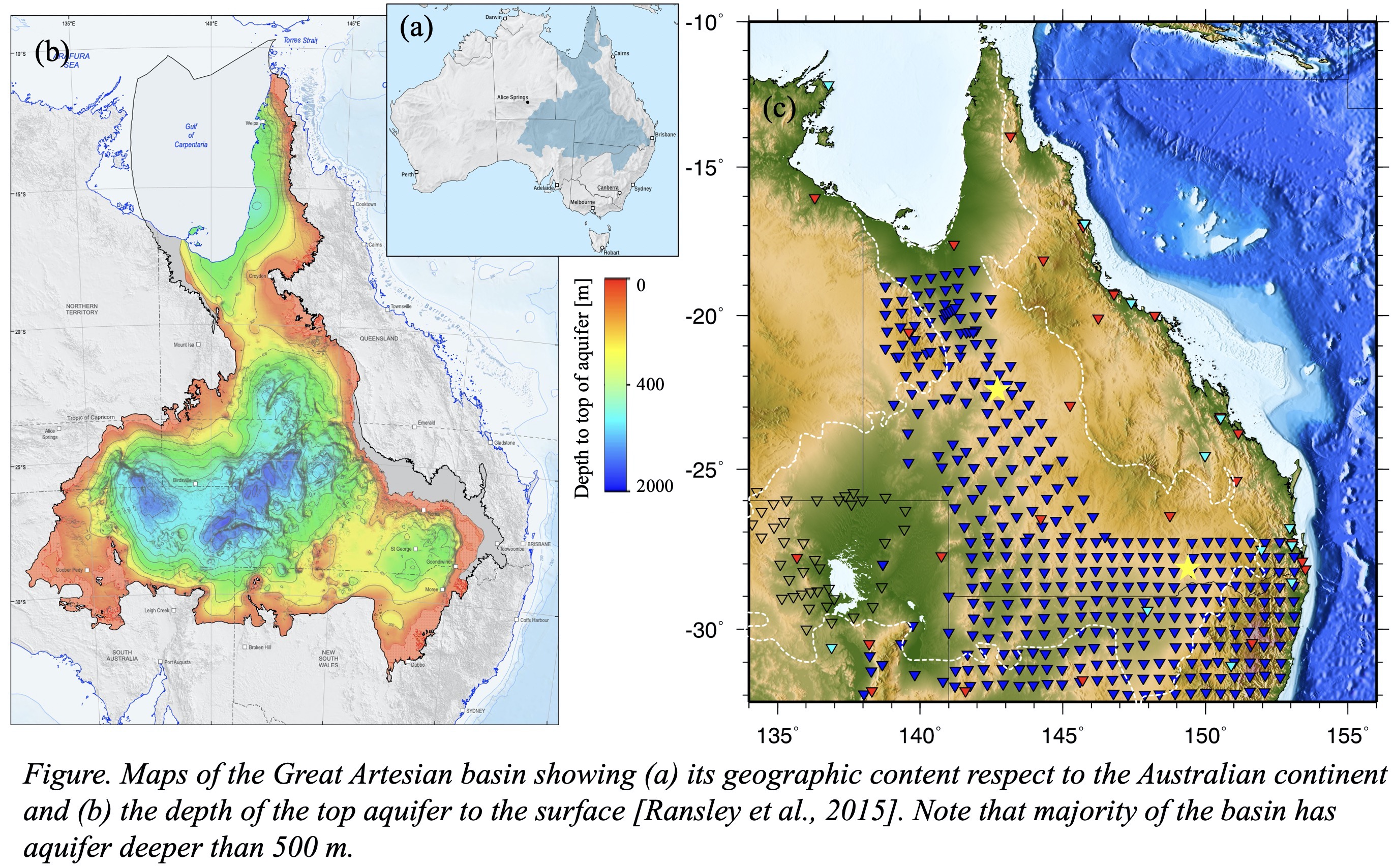
Australia is the driest continent on the planet and heavily relies on groundwater for residential, agricultural and industrial use. Managing this groundwater resource is of urgent socio-economic importance—but we currently face a serious gap in our understanding of the structure of aquifers, as well as how these groundwater systems respond to climatic and anthropogenic forcing. Current groundwater monitoring frameworks, such as well bore networks and satellite-based methods, are expensive for repeated measurements. In addition, they provide only local or regional scale information, leaving a key component of water management—the intermediate scale—to be further investigated. This project aims to fill this gap.
4-dimensional (4D) seismic imaging based on the ambient noise wavefield offers a promising solution. Several pioneering applications [Sens‐Schönfelder and Wegler, 2006; Lecocq et al., 2017; Clements and Denolle, 2018; Kim and Lekic, 2019] have demonstrated this method’s feasibility for sampling groundwater variations at the tens of km scale, across a broad range of temporal resolution, including daily, inter-seasonal, seasonal and long-term (>10 years) timescales. This technique leverages the ambient noise wavefield, which represents Earth’s background vibration stemming from ocean waves, storms, traffic, and other human activities. These sources provide naturally occurring and low-cost means for repeatedly sampling the shallow Earth, precisely where our groundwater systems are located.
This project aims to develop a data-driven, noise-based framework applicable for Australia for intermediate scale monitoring of groundwater dynamics, and we target at the Great Artesian Basin (GAB), the largest groundwater system in Australia, for a case study. We seek motivated students who are interested in exploring seismic approaches for groundwater monitoring. This project provides extensive opportunities for seismic data analysis, high-performance computing, potential numerical modelling and field work for new seismic data collections.
Reference:
- Sens‐Schönfelder and Wegler (2006). Passive image interferometry and seasonal variations of seismic velocities at Merapi Volcano, Indonesia. Geophys. Res. Lett., 33(21). https://doi.org/10.1029/2006GL027797
- Lecocq et al. (2017). Monitoring ground water storage at mesoscale using seismic noise: 30 years of continuous observation and thermo-elastic and hydrological modeling. Scientific reports, 7(1), 1-16. https://doi.org/10.1038/s41598-017-14468-9
- Clements and Denolle (2018). Tracking Groundwater Levels Using the Ambient Seismic Field. Geophys. Res. Lett, 45(13), 6459-6465. https://doi.org/10.1029/2018GL077706
- Kim and Lekic (2019). Groundwater Variations From Autocorrelation and Receiver Functions. Geophys. Res. Lett, 46(23), 13722-13729. https://doi.org/10.1029/2019GL084719
Members
Supervisor

ARC DECRA Research Fellow

Professor
ARC Future Fellow
Principal investigator
ARC DECRA Research Fellow
Collaborator

Professor
Associate Director Education